Comparison Of Density
In comparing the proposed Chapter 40B Local Initiative Program (LIP) Rice Pond Village project with direct abutters, those properties within 300-feet of the proposed project site (as determined by the Millbury Assessor), the proposed Chapter 40B LIP Rice Pond Village project will have a density of 29.5 based upon the development portion of the site (6.5± acres), whereas the existing immediate and surrounding neighborhood properties have a median density of 2.5. If you calculate the density over the whole site (16.0904± acres), then the density is 11.8, however, a large portion is part of the NationalGrid electricity transmission line easement (from South Main Street to the Providence & Worcester Railroad), Rice Pond, wetlands and various wildlife habitats, and therefore is unusable or inaccessible.
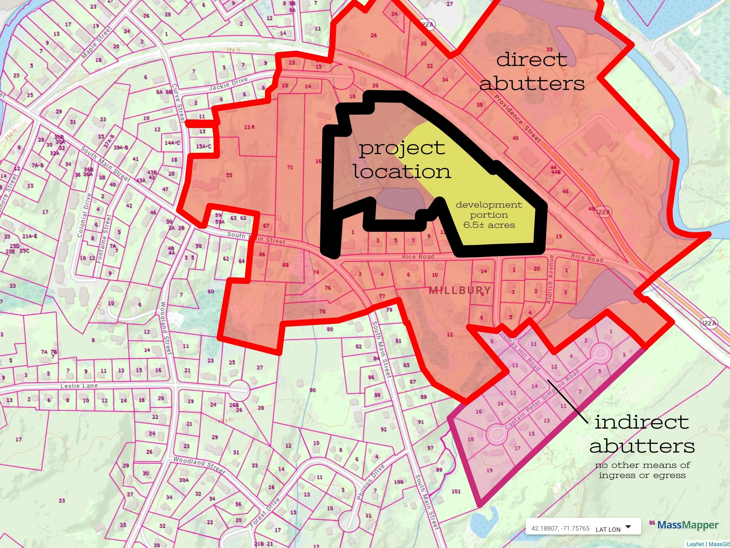
The area denoted in yellow is the intended area of development (6.5± acres) compared to the overall combined parcels of land (16.0904± acres) that contain an electricity transmission line easement, Rice Pond, wetlands and wildlife habitats, and other inaccessible or unusable areas due to topography constraints.
Density is calculated by taking the total lot area divided by the number of units. For example: if a ten-acre property contains 40 residential lots, the gross density is 4 units per acre (40-units/10-acres = 4 units/acre).

The proposed concentrated development impact will drastically increase the number of dwelling units from 53 to 245 in the same physical area as before. That is an explosive development rate that is greater than any other residential development in the town of Millbury. Not one multifamily development in the town of Millbury has 192-units, has as great a density of dwelling units, and none in such a concentrated land area.
If you compare the density, existing to proposed, the bar chart below illustrates the astronomical concentration of dwelling units that are proposed for an inadequate road that, as it is now, will not be able to adequately and safely handle the additional volume of traffic. Rice Road is a minor road with significant public safety problems that the developers, Steven F. Venincasa and James Venincasa have adamantly refused to address and/or mitigate.
Therefore, the proposed density with three (3) four-story apartment buildings with 192-apartments, as being proposed by Steven F. Venincasa and James Venincasa, are simply inconsistent and not compatible with the nearby architectural structures, typology, density, building massing, scale, and integration into existing development patterns in the town of Millbury, not to mention that there is only a planned single access point of ingress/egress on an inadequate road. Please refer to the Massachusetts Handbook: Approach to Chapter 40B Design Reviews.
Our neighborhood has faith in the Millbury Board of Appeals and the Massachusetts’ Department of Housing and Community Development (DHCD) will apply a similar “common sense” analysis to the proposed Chapter 40B LIP Rice Pond Village project and arrive at similar conclusions to MassHousing’s denial of the Medfield Meadows.
A Logical Comparison
As previous documented, Medfield Meadows was a proposed Chapter 40B project that proposed 200-units on the north and south sides of Route 27 that was denied by MassHousing. The developer came back later with a proposed Chapter 40B LIP project, named Medfield Green, and was approved with only 36-units, an 82% reduction in magnitude with more appropriately sized buildings that fit in better with the scale of the existing neighborhoods and streetscape.